

The population of Australian Capital Territory (ACT) is in the region of 380,000. The total area of the territory is a fraction over 2,400 square kilometres; tiny by Australian standards. The Capital Territory is surrounded by New South Wales, with the capital Canberra surrounding Lake Burley Griffin, which is man made.
The Australian Capital Territory stretches 88km from north to south and only 30km from west to east. The landscape around Canberra is made up of rugged plains, hills and mountains, as well as plenty of trees. This countryside leads into New South Wales from all directions, with most of the landscape being National Parks.
 Roughly 45% of ACT is made up of the Namadgi National Park. There are plenty of walking trails around Canberra, and some beautiful barbecue areas where you can stop along your journey.
The Murrumbridge River runs from south east to north west and offers some great swimming spots. These include the Black Mountain, Casuarina Sands, Cotter Dam, Gibraltar Falls, Kambah Pool Reserve, Point Hill Crossing, Pine Island and Uriarra Crossing. About 30km north of Canberra is Bywong, a replica of an old mining town and settlement.
 30km south is the Lanyon Homestead, where the buildings and landscape are truly beautiful. A collection of artwork by Sidney Nolan is housed at the Canberra Museum and Gallery.
In addition, there are several pretty towns around Canberra and ACT which are worth visiting en route, including Braidwood, Bungendore, Gold Creek, Queanbeyan and Tharwa.
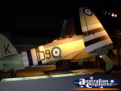
Australian Capital Territory is rich in galleries and museums including the Australian War Memorial which has amongst other things an Aircraft Hall.
A Little History
In 1901 a decision was made to develop a national capital. The move was as a direct result of the federation of colonies in Australia. However, it wasn't until 1908 that the location of the capital had been decided.
The location was a compromise between the two rivals Melbourne and Sydney. This explains why the capital is roughly between the two states; although slightly closer to Sydney.
Who was to design the city, was decided by way of an international competition which was won by an American architect named, Walter Burley Griffin.
Canberra was the name given to the new capital which is rumoured to be a translation of 'meeting place' in aboriginal. Slow progress was made, and until 1927 decisions were still made in Melbourne until parliament was convened in Canberra.
The depression put a further dampener on the developments. In fact things didn't really start happening until well after the Second World War.
The Australian National University opened in 1946 followed by the Canberra School of Music in 1965.
Points of Interest
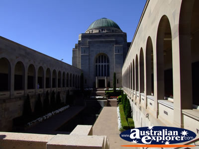 Australian War Memorial
Canberra is home to the Australian War Memorial which opened in November 1941. Combining a shrine, world-class museum together with an extensive archive the Australian War Memorial pays tribute to the sacrifice of Australians who died at war.
The Australian War Memorial is open everyday between 10.00am-5.00pm and located at Cnr Treloar Crescent & Anzac Parade, Campbell ACT 2612.
The Floriade Festival
If you like flowers, this festival is for you. Essentially a stunning display of Canberra's spring flowers from mid September to mid October. Find out more about the Canberra Floriade Festival
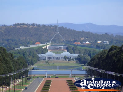
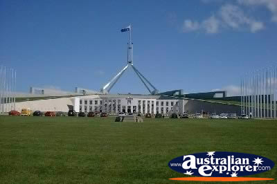 Parliament House
Upon Capital Hill rests a huge four legged flag mast that marks the location of Parliament House. The building cost around $1.1 billion dollars and took seven years to build. It is 300 metres wide and 300 metres long and its roof is covered with grass. With a good percentage of the building open to the public between 9am and 5pm this is well worth a visit. Parliament House is located on Parliament Drive, Canberra ACT 2600.
Australian Capital Territory Facts
* Australian Capital Territory Area: 2,358 square kilometres
* Australian Capital Territory Capital: Canberra
ACT, ACT Accommodation
Top Australian Capital Territory Destinations
| Canberra |
| ACT National Parks |
Gold Creek |
Lake Burley Griffin |
| SHARE with |
